Two of the best summit views in North Georgia sit within twenty minutes of each other. One is Georgia’s highest point, well-signed, with a paved spur and a visitor center. The other is a smaller mountain reached by a road that’ll test whatever you brought in the way of clutch control and nerve. Base a day out of Hiawassee and you can ride both, back-to-back, with time for lunch in between.
This is a guide to that ride. Brasstown Bald first, because it’s the safer bet if the weather turns and it earns you the bragging rights. Then Bell Mountain, because if you’ve just come off Brasstown you’re warmed up and ready for the road that most riders come away talking about.
The Route at a Glance
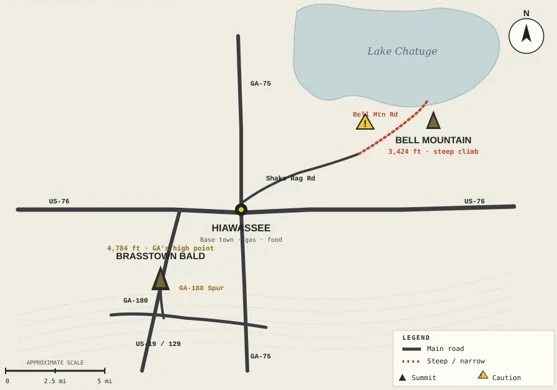
Both peaks share Hiawassee as their natural jumping-off point. Brasstown Bald sits to the south-southwest, Bell Mountain to the northeast. The whole loop, done as an out-and-back for each, runs roughly 40 to 50 miles depending on how much extra pavement you thread in — easily a half-day, plus stops.
Peak 1: Brasstown Bald (4,784 ft)
Georgia’s highest point sits at the end of the GA-180 Spur, a short but steep and twisty two-lane climbing off GA-180. The Spur has a couple of rougher spots near the bottom worth taking easy, but it’s straightforward riding — the challenge is elevation change more than technique. From the visitor-center parking area at the top of the paved section, you either hike the roughly half-mile trail to the summit or take the shuttle.
The summit itself has a 360-degree observation deck with long-range views into Tennessee, North Carolina, and South Carolina on a clear day. On a hazy summer afternoon you’ll still see plenty, but if you can pick a clear morning, do it. There’s a small parking fee at the visitor center.
For a rider, this is the crown jewel of the region — the highest you can get on a paved road in the state, with the panoramic payoff to match. It also serves as the natural first stop of the day because it’s the more predictable of the two peaks. If Bell Mountain gives you second thoughts later, at least you’ll have Brasstown in your pocket.
Peak 2: Bell Mountain (3,424 ft)
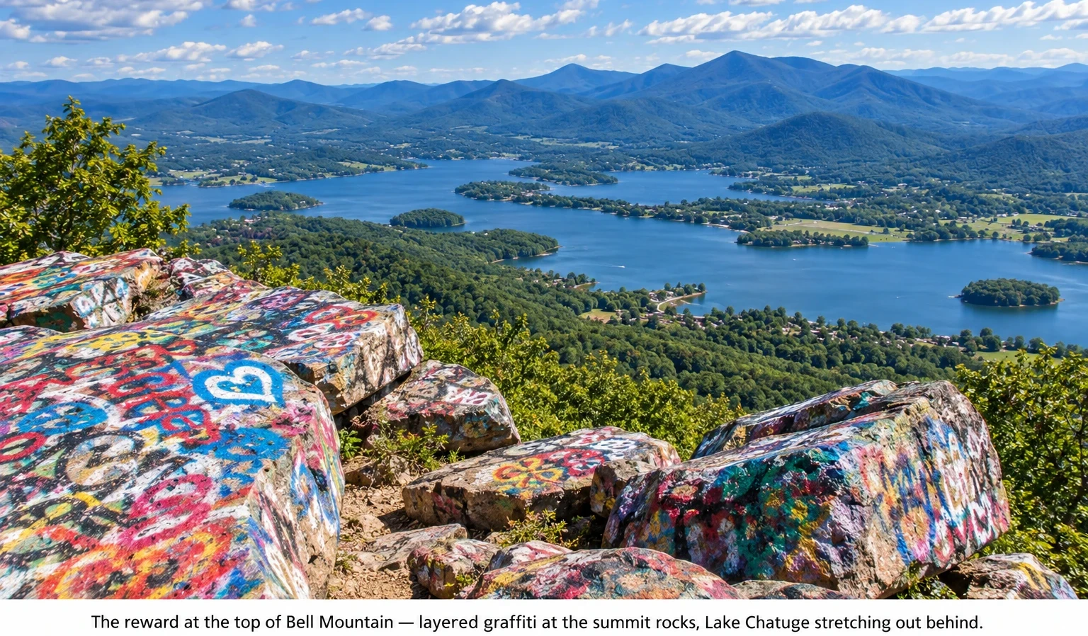
Bell is smaller than Brasstown by about 1,300 feet, sits above Lake Chatuge, and has its own character. The summit is bare rock covered in decades of layered graffiti — rocks, walls, every flat surface. It’s divisive. Some riders love it as a raw, community-made mark on the mountain; others find it detracts from the natural view. Either way, it’s unique. The panoramic view over Lake Chatuge, with the surrounding ridges rolling out to the horizon, is genuinely one of the finest in North Georgia.
It’s free to visit, opens dawn to dusk, and has small paved parking areas partway up and at the summit. The observation deck at the top adds a few more feet of vantage and is worth the short walk up the stairs.
But the story isn’t the summit — it’s the road that gets you there. Which brings us to the section that earns Bell its reputation.
The Road to Bell: What You Need to Know
Access is from downtown Hiawassee: head east on US-76 (Main Street), turn left onto Shake Rag Road, and follow it about a mile and a half to the fork where Bell Mountain Road turns right and starts climbing. Shake Rag Road itself is a benign approach through fields and rural homes. The character change happens where it meets Bell Mountain Road.
From that turn to the top, you’re on what locals and reviewers alike call a paved 1.5-lane road — not quite one lane, not quite two. The pavement is decent but the width isn’t. There are switchbacks. There are hairpins. There are almost no guardrails in the exposed sections. And the grade is steep, especially the final stretch — steep enough that a driver in a full-size pickup described losing sight of the road ahead over the hood.
For a motorcycle, this is a road that rewards clutch and throttle control and punishes complacency. A few practical realities:
• Mountain right-of-way applies. If you meet oncoming traffic and there’s no pullout, the vehicle heading down backs up to the nearest one. Uphill has the right of way. Know this before you go, because you’ll almost certainly need it.
• Bikes with aggressive ergonomics will feel it. The steep grade combined with tight low-speed switchbacks is a real workout on a hyper-naked or a sport bike — a lot of clutch feathering at high revs. Cruisers and big touring rigs are the wrong tool for this road; the tight turns and steep pitch don’t play nice with long wheelbases and heavy weight.
• Watch for cars stopping unexpectedly. Some drivers get to the parking area partway up, see the “WARNING STEEP GRADE” sign, and abandon the climb rather than continue. That means slow or stopped vehicles at unexpected moments — do not assume anyone ahead of you is committed.
• Avoid wet weather, and never attempt in ice. The grade combined with narrow pavement and blind corners is unforgiving. There are stories, some local and some visible in the form of debris off the shoulder, of vehicles that misjudged conditions.
• Come down slower than you went up. The natural pull of gravity, plus the tight blind hairpins, plus needing to yield to uphill traffic — the descent is where most riders find themselves overcommitted. Low gear, engine braking, easy on the front brake.
None of this is meant to scare anyone off. Riders do Bell every day and come back grinning. But it is unambiguously the more character-testing of the two climbs, and going in with the wrong bike or the wrong expectations turns a great day into a bad one.
Making It a Day
Base in Hiawassee. Fill the tank before you leave town — the loop isn’t long but there are no services on either climb. From downtown, head south on US-19/US-129 to GA-180 East (Jack’s Gap), then follow GA-180 to the Spur turn. Climb to the Brasstown Bald visitor center, park, do the summit, and come back down. That’s the first half.
Return to Hiawassee for lunch. There are good options on the square and around it, and the town works well as a mid-day reset.
For the second half, head east from downtown on US-76 (Main Street), watch for Shake Rag Road on your left, take it about a mile and a half, and turn right onto Bell Mountain Road when you see the sign. Climb slowly, park at the summit lot, and take in the view. Come back down slower than you went up.
The total loop, done at a relaxed pace with stops and lunch, fills a comfortable half-day. Do it clockwise (Brasstown first) or counter-clockwise (Bell first) — the order doesn’t matter much except that Bell is the more mentally demanding of the two, and some riders like the confidence boost of putting Brasstown first.
Practical Notes for Both Peaks
Fuel and food. Hiawassee has your services. Neither summit has fuel or food beyond a small gift shop at Brasstown’s visitor center. Top off before you climb.
Cell service. Spotty at both summits. Bell in particular tends to lose signal. Download offline maps and don’t bet the ride on your phone.
Timing. Both peaks are best in the morning or on clear afternoons. Peak fall (mid-October to early November) brings genuinely large crowds, especially at Brasstown Bald. Expect to wait for parking and to share the road.
Weather. Both summits sit hundreds to thousands of feet above the town. Temperature drops of 10–15°F are normal. Pack a layer, even in summer.
What Bell Mountain isn’t. It is not a place to take a fully-loaded touring bike, a passenger who’s uncomfortable with heights, or a rider having a low-focus day. Save it for a clear day, an alert head, and a bike that suits it.
3 Key Takeaways
1. Both peaks in one day is easy — and worth doing. Base in Hiawassee, top off with fuel, and plan a half-day. Brasstown first, lunch in town, Bell in the afternoon (or reverse). The whole loop runs 40 to 50 miles with the two climbs included.
2. Brasstown is the crown jewel; Bell is the character test. Brasstown Bald gives you Georgia’s highest paved point and a proper visitor-center experience. Bell gives you a shorter climb, a unique graffiti-summit vibe over Lake Chatuge, and a road that tests your skills.
3. The road to Bell earns respect. Paved but 1.5-lane wide, steep hairpins, few pullouts, and steepest at the top. Uphill has right of way; downhill backs up if you meet. Not the day for a big touring rig, wet conditions, or a distracted head.
3-Point Summary
The pairing: Brasstown Bald (4,784 ft, GA’s high point) via GA-180 Spur, and Bell Mountain (3,424 ft, above Lake Chatuge) via Shake Rag Road and Bell Mountain Road. Both share Hiawassee as their base town.
The route: About 40–50 miles total as an out-and-back for each summit. Half-day with lunch in town. Ride order doesn’t matter, but putting Brasstown first eases you into the day.
The Bell climb: Steep, narrow, hairpin-heavy paved road. Requires clutch and throttle control, mountain right-of-way etiquette, and the right bike. Reward at the top is one of the finest views in North Georgia.
The Bottom Line
This is one of the better half-days in North Georgia when you approach it right. Two summits, two different characters, one small town anchoring the middle. Brasstown is what you brag about later; Bell is what you talk about that night. Ride both.
Have you ridden the Bell Mountain climb? Drop your take in the comments — especially if you have a bike recommendation for that grade.